President's Message
My, how fast a year can go! Here we are approaching the last quarterly meeting of 2022. Time to reflect on what an exciting year it has been! I hope you have been visiting HCHS Facebook page where our events and field trips have been shared: the completion and dedication of the replica 19th century kitchen at Meadow Farm; a visit to the Pamunkey Indian Reservation for Museum Day; Glen Allen Day; a walking tour of Yorktown with the Revolution Round Table of Richmond and a return for Yorktown Day; an archaeological dig with the Wolf Creek Cherokee Tribe; a visit to James Madison's birthplace at Belle Grove and a visit to Patrick Henry's Scotchtown for a "Home for the Holidays" event.
While it is always a pleasure to visit our neighbor, Hanover County, a little known fact is that of the association of Patrick Henry with Henrico County. At the time of Patrick Henry's famous "give me liberty or give me death" speech, the location of Town Church (which later became St John's Episcopal Church) was still under Henrico County jurisdiction, as the site of the Second Virginia Convention. In January of 1775 a call went out to meet at Richmond, Henrico County on March 20. The First Virginia Convention had assembled in Williamsburg on August 1, 1774, at which delegates to the Continental Congress were elected. Later as the disagreements with British rule progressed, a third Virginia Convention was called on June 26 and convened on July 17 at the same location of Town Church in Richmond, Henrico County.
Those attending the Virginia conventions in the company of Patrick Henry were George Washington, Thomas Jefferson, Richard Henry Lee and others, later referred to as "Founding Fathers" who fought for independence and established the United States of America.
With Virginia as the first of English colonies and Henricus (later Henrico County) as the second settlement after Jamestown, independence from England was declared in 1776. Williamsburg became capital of Virginia for three years. In 1780 the capital was moved to Richmond. Then, Governor Thomas Jefferson thought Williamsburg to be vulnerable to British attack.
Richmond became a town (still part of Henrico County) in 1742, incorporated as a city in 1782 and completely independent in 1842. And so, at the time of the American Revolution, Henrico County played a huge roll and yet that history through divisions and annexations has been, for the most part, lost in time.
The Henrico County Historical Society was founded as part of the bicentennial commemoration, and so HCHS will be celebrating our 50th anniversary along with the national 250th commemoration of the American Revolution. Much to celebrate, more to come!
Blessings to all at this holiday season.
Sarah Pace,
President
>Back to Top<
December Meeting
Join us at our last meeting of 2022! It is scheduled for Sunday, December 4th, starting at 2:30p.m.
The meeting will take place at the Dorey Recreation Center, which is located at 7200 Dorey Park Drive, Henrico, VA 23231.
Our speaker is Tom Lappas. Mr. Lappas is the owner and publisher of The Henrico Citizen, and will tell us why "A smarter Henrico is a better Henrico".
>Back to Top<
Dues Renewal
Please take few minutes to fill out the attached envelope, write a check, stick on a stamp and join us for another year of promoting Henrico County history.
If you would prefer, you can go to the society's website at www.henricohistoricalsociety.org/shopping.html and pay your dues on line.
If there's no envelope here, you must be one of our Life Members, a sister organization or a recipient of a gift membership.
We thank you all for your support.
>Back to Top<
HCHS Half Price Holiday Sale!

HCHS Half-Price Holiday Sale runs from November 25, 2022 through January 1, 2023.
Visit our shop at www.henricohistoricalsociety.org/shopping.html.
Take a look and find:
- A lovely Williamsburg blue coverlet with images from Henrico County.
- Two different sizes of prints of both Walkerton Tavern and Dabbs House.
- Books containing historical information about Henrico County.
- Past issues of our society magazine and calendars filled with pictures & facts.
HCHS Half-Price Holiday sale - check it out!
>Back to Top<
In Memorium: Mary Anne Nelson
We offer our deepest sympathy to the family of Mary Anne Nelson.
September 22, 1946 - October 18, 2022.
>Back to Top<
Inventive Henricoans
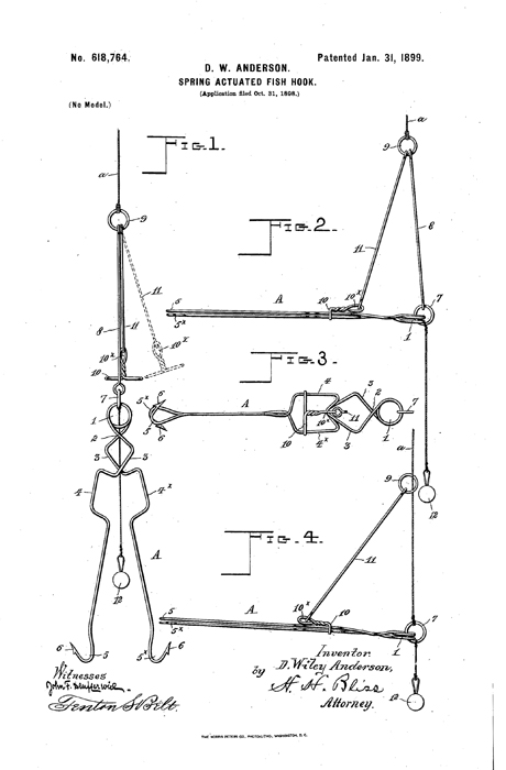
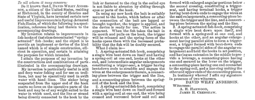
D.W. Anderson was apparently an avid fisherman. Perhaps, the energy he saved by not having to set the hook when a fish struck his bait he expended in designing this rather complicated piscatorial mechanism. His explanation of the device is quite long. This description of the parts has been edited, and the basic way the device functioned has been reproduced along with his claims for originality.
>Back to Top<
For Nearly 200 Years Bosher's Dam has Tried to Reign in the James
In the early 1960s, my friends and I were "free range" children, wandering on foot and bicycle all over the west end of Henrico County. Although we were unaware of it at the time, some of our favorite haunts were sites connected to the county's history. There was a pond we called Timber Lake in the woods off Quioccasin Road in the area of the early coal mines. I remember seeing the remnants of a narrow gauge railroad on a rise on the then undeveloped south side of Patterson Avenue. We climbed on the Westham Gauge; and farther upriver was one of my favorite places - Bosher's Dam, a 12-foot brick and Petersburg granite dam at mile 113 on the James River (It's actually 14 feet tall structurally when its foundation is taken into account).
I thought it was really wonderful to climb onto the dam's abutment. Today, I think it's really wonderful that the structure in its several iterations has withstood the forces of the river and its floods for over two hundred years.
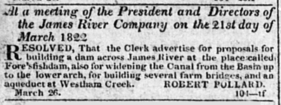
However, it was not the first dam at the site. It was preceded by Fore's Fish Dam, an eighteenth - century structure apparently designed to aid in trapping fish and named after Thomas Fore from whose Chesterfield County land the dam extended. In the 5 April 1822 Richmond Enquirer, the James River Company advertised for "proposals for building a dam across James River at the place called Fore's fishdam." Eleven days later in the 16 April 1822 Richmond Enquirer, James River Company President James Coalter's announcement notified John E. Fore, "orphan of Thomas Fore deceased," to go to the Chesterfield May court to "assess the damages which will result in your land bordering on James river in said county, from the erection of a dam across the said river, and also to assess the damages you will sustain, from the occupancy of so much of said land, by the same company, as may be necessary for the abutment of said dam."
The proposed dam would supply water to the James River Company's canal, which would be deepened and widened as the Commissioner's Report in the 13 February 1824 Constitutional Whig indicated. Construction cost of the dam can be found in the 1830 Annual Report of the Board of Public Works to the General Assembly. It contains a report on lock and dam improvement and states, "We have also had dams built in Virginia, and on this very James River. . . the most expensive . . . Bosher's dam, 980 feet long, 11 1/4 high, has cost $17,992." Fairly soon after the dam was built, it seems to have experienced difficulties. According to the 28 February 1829 Richmond Enquirer, colliers, who used the dam-fed canal to transport their coal had petitioned the House of Delegates to pass an act "providing for the raising and repairing of Bosher's Dam" as well as "the locks below the basin.", the bill passed, but the first call for labor didn't seem to come for a while when an advertisement in the 31 August 1830 Daily Richmond Whig called for "Forty able bodied hands to work at Maiden's Adventure and Bosher's Dam who will be paid 75 cents per day and found, each hand furnishing himself with a shovel or peek."
That structure was clearly not substantial enough because high water in 1834 swept away a 153 - foot section at the south end that required significant rebuilding. The work done in 1835 resulted in a dam 11 feet high, 16 feet wide and 900 feet long, essentially, it seems, the structure that is there today. The annual report to the stockholders of the newly - named James River and Kanawha Company in 1836 itemized "Expenses incurred in the reconstruction of Bosher's Dam, including the River Lock and Fish Slope." It indicated a total of $7,261.63 spent on the project that required over 10,000 feet of planking and 556 perches of stone, roughly 14,000 cubic feet.
As indicated in the report, 1835 dam and its predecessor both had a section for fish migration called a fish slope. The original fish slope was 96 feet wide, and the 153-foot section that washed away in 1834 was the section between that and the southern shore. However, the accommodations to fish traveling in the river did not extend to people trying to travel across the river; and while citizens of Henrico and Chesterfield petitioned the committee of roads and internal navigation of the House of Delegates for "the establishment of a public ferry across James river, at some point near Bosher's dam," the petition was rejected.
Repairs were regularly required on the dam. The 1 March 1841 Daily Richmond Whig reported that "upon a foundation of brush, wood and stone, four cribs of stone, well connected together, have been sunk and fastened to the dam, so as to support and secure it against high waters." It also indicated that the old slope had been repaired. The paper's assertion that "the dam might last for several years longer, without any expense other than to tighten it at the bottom" was quite an underestimation.
Its security against high waters apparently needed strengthening because high waters a few years necessitated raising the height of the dam. The Annual Report of the Board of Public Works to the General Assembly of the First Division James River and Kanawha Canal stated that the new height was "one foot above the level of the fresh of 1847" and that the northern abutment had been taken down "as low as practicable and rebuilt with solid cement masonry."
In 1856, the company advertised in the 4 November Richmond Enquirer for proposals for three different options for work on Bosher's Dam: for repair and maintenance for two years, for rebuilding out of wood, for rebuilding out of stone.
It is difficult to tell whether extensive repair or rebuilding out of stone was the chosen solution. Phrasing in reports of the following years suggests rebuilding, while the outlay of funds reported seems a bit small. Nevertheless, the work was significant. Superintendent Charles Bolling in the 1859 Report of the Board of Public Works to the General Assembly noted that "There has been a section of the dam built and coped from the north abutment 337 feet in length," and went on to say, "There yet remains about 350 feet to be built." That total measurement falls short of a total rebuild of the dam by over 100 feet.
Bolling estimated that the entire project would "occupy the whole of the next year in its completion." But the next year's company report to the Board of Public Works noted that "about 815 feet in the length of the dam is fi nished" and anticipated it would be completed by January of the next year. The total cost of those 815 feet of dam had been "about $51,000," and the additional construction was estimated to cost another $10,000.
However, the completion of that work would be a bit longer than anticipated. In its 1861 Report to the Board of Public Works, the James River and Kanawha Company's chief engineer E. Lorraine cited the drain on "the mechanical labor of the country by the war" and "the frequent freshes which have so interrupted the progress of the work" delayed its completion. He went on to claim in a rather colorful manner that "the new plan of stone dam with wooden covering, which I have adopted, is well calculated to resist the most impetuous assaults of James river."
Exactly when work on the dam over that impetuous river was finally completed is unclear, and whether or not it was a complete reconstruction is as well. Later work in 1895 seemed to suggest that the work had been extensive but not a total rebuilding. The 1896 Annual Report by the City Water Works recounts work done on the north wing of the dam during which workers "had to cut through two old crib-dams which are submerged." These may well have been the cribs attached to the dam in the 1841 work earlier mentioned. And when they were removed, the report cites "the wretched condition and original bad construction of the masonry" and adds, "why it had remained standing was remarkable."
No matter whether the work from the 1860s was reconstruction or repair, by 1872, further changes were needed because calls were being made for fishways in the James River dams to allow the passage of migrating fish. In that year, the Report of the Fish Commissioner included in the Journal of the Senate of the Commonwealth of Virginia indicated that implementing a two-year old plan for such a passage through Bosher's Dam was estimated to cost $1,400 but that it could probably be built for between $700 and $800.
Apparently, an act by the General Assembly authorizing the transfer of the James River and Kanawha Company's canal properties to the Richmond and Allegheny railroad called for the erection of fishways on those "twenty-three dams on James river and its tributaries." Whether it cost $700 or $1,400, a fishway was constructed on Bosher's Dam. An 1882 report on Fishways on James River in the Commission of Fisheries annual report stated, "A single fishway - that one over Bosher's dam - has been erected in compliance with this law," with hopes to finish it by spring of that year.
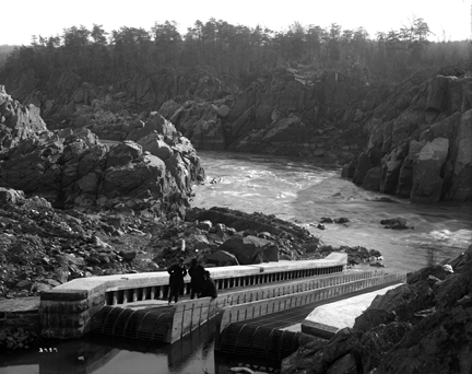
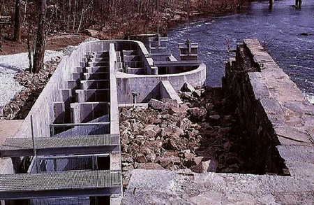
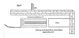
That fishway, according to the Annual Report of the Commission of Fisheries of 1883, had two arched culverts to "admit the water to a sluice way which conducts it to the head of the fishway." That design, however, required some post - construction modification because the water was discharged from it "too far from the dam to secure the best results." It called for a deflecting wall at the lower end to turn the current around the abutment. How long that feature lasted is unclear. In 1909, the magazine Fish Scraps noted that a fish ladder "of the design of Col. M. McDonald is in operation at Bosher's Dam." However, the 1915 Opinions of the City Attorney of Richmond included a letter written by the Assistant City Attorney Geo. Wayne Anderson to the city's Commission on Finance advising that the city was not responsible for the construction of a fish ladder at Bosher's Dam. It appears that somewhere in the interim between 1915 and 1919, the fishway disappeared. At any rate, today's Bosher's dam features a 13 - slot fishway with 55 raps that was constructed on the north bank in 1999. So with the completion of the new fishway, shad and the other migratory fish are now able to roam more freely, like me and the "free range" friends of my youth.
Joey Boehling
Thanks to Alan Weaver, Fishway Coordinator, Department of Wildlife Resources.
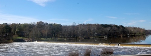
Bosher's Dam. This lowhead dam, seen here from the Willey Bridge, is approaching its 200th year. It was built on the site of Fore's Fish Dam, named for the property once owned by the Fore family where the dam's southern abutment is located today. Photo by Mary Boehling.
McDonald Fishway. Officials from the U. S. Fish Commission inspect the fish ladder at Great Falls on the Potomac. The same type of fishway was constructed on Bosher's Dam in the late 1800s.
Coming attraction. The 5 April 1822 Richmond Enquirer announces the James River Company's plan for Bosher's Dam.
New and old fishways. The photograph at the left shows today's modern fishway at Bosher's Dam, while the drawing below from The 1884 Annual Report of the Commissioner of Fisheries of the State of Virginia shows the dam's fishway on the north side of the river in the late 1800s.
>Back to Top<
Now You Know
It's a Trap!
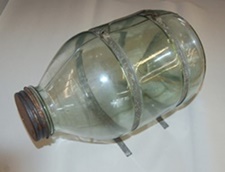
We congratulate Mary Jo and Haywood Wigglesworth for identifying the "What Do You Know?" object in the last issue, and we thank Mitchell Snow for allowing us to feature his vintage glass minnow trap. It fit this issue's seeming fascination with things riparian.
To use the trap, one would place some sort of bait in the body of the jar and put the trap in a stream with the funnel end facing into the flow. The doomed minnows would swim into the jar; but like the flies in the fly trap we showed in a previous issue, they would not be able to get out.
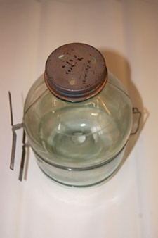
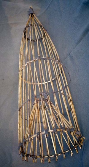
The same concept was used by Native Americans, who produced basket-like traps like the one depicted at the far right. That trap could be used by placing the wide end at the point of a fish dam or weir, where the fish would be "funneled" toward and into the trap. The funnel-shaped part of the trap would then prevent the fish from escaping.
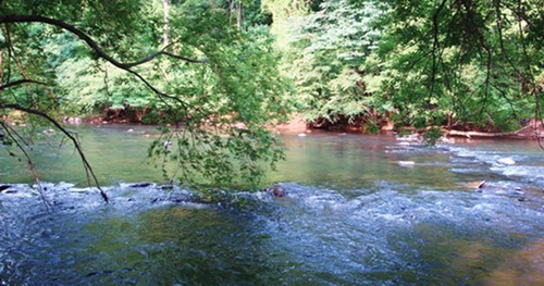
Such a trap might have been used at the point of the "V" of the Martinsville Fish Dam on the Smith River seen in the photograph above. Fore's Fish Dam might have been similar to that, although it is hard to imagine it extending all the way across the James River.
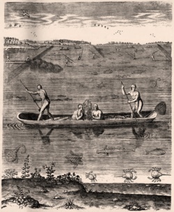
Seen at the right is Theodor de Bry's "Their Manner of Fishynge in Virginia," an engraving from Thomas Hariot's 1588 book A Briefe and True Report of the New Found Land of Virginia. It depicts Native Americans fishing from a canoe and at weirs.
>Back to Top<
What Do You Know?
This wooden object is 16 inches long and 8 inches wide at the widest point. On the flat side are two small metal-lined holes and a circular metal disc 11/2 inches in diameter with five screws in it.
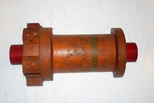
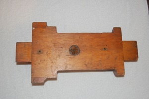
Do you know what it is? Email your answers to jboehling@verizon.net.
We look forward to hearing from you.
>Back to Top<
News 2022: Fourth Quarter
First Quarter | Second Quarter | Third Quarter
Home | Henrico | Maps | Genealogy | Preservation | Membership | Shopping | HCHS
|


